My Top 5 Trail Running Routes in the Peak District
Part 1: Dark Peak
Peak District offers the perfect playground for trail running – also known as fell running. From gentle rolling hills with good trails suitable for everyone, to gruelling mud-fests with thousands of feet of ascent, despite its small size, the Peak District National Park has it all. Due to its compact layout the Peak District is very accessible both by car and by public transport. And you rarely have to travel for ages to explore a new area. These trail running routes are also suitable day hikes if you prefer a slower pace!
My Favourite Peak District Trail Running Routes
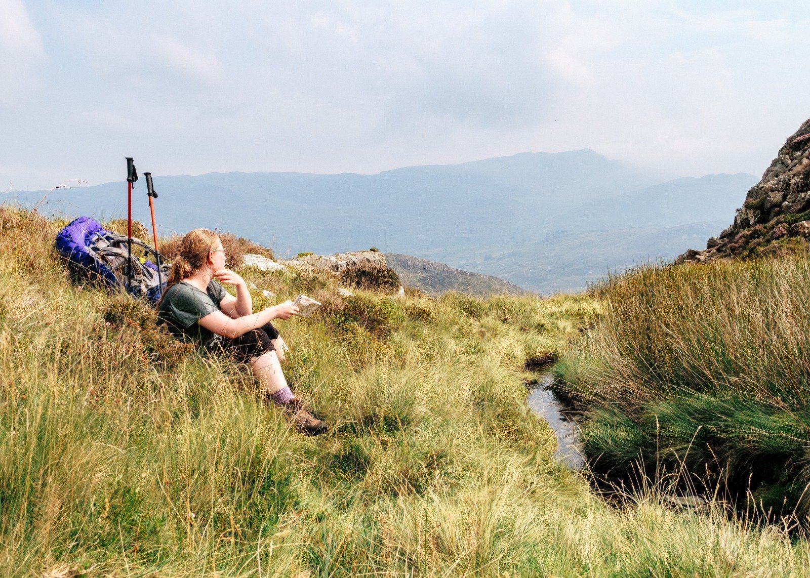
1. Win Hill and Hope Cross from Bamford
- Distance: 13km/8mi Elevation gain: 460m/1520ft Trail surface: Good trails and gravel roads Difficulty: Medium
Route Summary: A loop of Win Hill, Hope Cross and Ladybower reservoir.
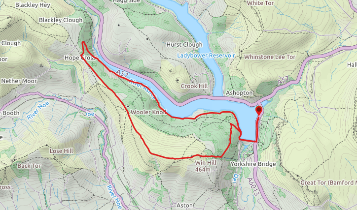
Route Description: Win Hill gives you some of the best panoramic views the Peak District has to offer, coupled with excellent trail running. The Ladybower and Derwent Reservoirs in the north, a view over the peaks surrounding Edale Valley in the east and the classic edges of Stanage and Bamford in the west. This run starts by parking on the A6013 near the Ladybower Dam. A sidewalk leads to the dam, cross this and prepare to feel the burn as the path quickly turns uphill. There are many trails leading up to the summit of Win Hill – feel free to freestyle your ascent – as long as you keep going up you will reach it eventually! The description here is chosen for its nice even elevation gain all the way to the top.
After the dam turn right onto the single-track road – you will soon spot a path turning off on your left. Follow this as it starts to climb up the hillside. After roughly 400 meters a junction is reached. Turn left onto the path which keeps gently climbing up as it winds itself around the hillside. Follow this just under a kilometer before another paths turns directly uphill. Now is time for the last push to the summit. From here the path keeps steadily climbing up until the summit of Win Hill (463m) is reached just after three kilometers into the run. After taking in the view at the trig point, weave your way down from the top to the track leading west along the crest of the sloping ridge. Jog gently downhill until the path reaches the edge of the forest at Wooler Knoll.
Keep following the wall and the forest’s edge until Hope Cross before turning right onto a track through the woods. There are several trails crisscrossing their way through the forest. For this run we followed the main path until a junction where a cluster of ruins is visible on the forest bed. From here turn right to a path which cuts diagonally down the hillside towards the reservoir – for a steeper option head directly down the hill. Both of these options will reach the gravel road above the Ladybower Reservoir. Turn right onto this and keep your legs working as it is now time for a steady 5 kilometer jog back to the car.
Access: There are a few options for parking for this run. An ideal starting point is a layby just above the Ladybower dam on the A6013 at grid reference SK 20219 86029. Alternative options are lay-bys a bit further down the road towards Bamford village and by the Yorkshire Bridge Inn. It is usually also possible to park at the Inn if finishing your run with a well-deserved meal. There is also a large pay and display car park at Heatherdene at grid reference SK 20198 595, however this often fills up early. Note that it is crucial to park considerately and only in dedicated lay-bys in this area. The road is a dedicated clear way and illegally parked cars are frequently ticketed.
This run can also be accessed by taking a train to Bamford Station, which is on the Sheffield – Manchester mainline, and walking to the starting point, roughly 3km/2mi. Alternatively there are daily buses stopping at the Heatherdene stop or the Yorkshire Bridge Inn.
2. Mill Hill from Chunal Moor
- Distance: 10km/6.2mi Elevation gain: 380m/1250ft Trail surface: Mix of hard and rocky with muddy sections Difficulty: Medium
Route Summary: Harry Hut, Mill Hill and Kinder Reservoir from Chunal Moor.
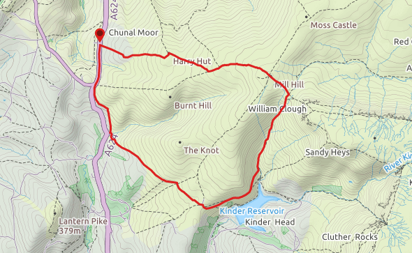
Route Description: This route has everything you want from Peak District trail running. Start high up on Chunal Moor. Firstly, cross the stile from the parking onto the moor and follow the good but at places narrow path gently uphill to the summit of Harry Hut (441m). From the trig point a well-worn path across the moorland leads in a southeast direction (take care to not accidentally take the path leading northwest which quickly starts to drop down towards Glossop).
This section of the run can be notoriously boggy and gives you a very authentic fell running experience with frequently wet and muddy feet even after a dry spell. After less than a kilometre a flagstone path is reached. Turn left onto this and keep following it as it gently winds itself up the moor. In good visibility you will soon start to see the edges of Kinder Plateau ahead. After a last little rise, the flagstone path leads you to a cairn – this is the summit of Mill Hill (544m) and your high point of the day. Say bye to the flagstones as a short downhill section on a gravel paths directly ahead leads you to a second cairn and a junction. Here the steep rise ahead leads to the Kinder Plateau, but this run turns right to follow William Clough downhill towards Hayfield.
This section of the run is full of interest with narrow sections and rocky steps as the path winds itself down the clough, crossing the little stream at multiple points. After a while lovely views down over Kinder Reservoir open up ahead of the trail. Instead of dropping down to the reservoir, take care to stay on a higher path contouring round the hillside. This not only gives you the best views but also makes it easy to follow the path as it starts to curve back towards the starting point of the run. Upon reaching a junction with a little shooting cabin visible just above you on the moor. Take the right fork which leads you onto a bridge built across an especially wet section.
From here you are on the home straight. The path keeps very gently dropping down until you can see the road below you. Just before reaching it, the path turns right to run parallel to the road. Cross a gate and run up the last shortlived hill (take care to stay parallel to road on your left, instead of turning back up the moor on your right). This brings you to a path junction and a wall, cross the stile on your left on to the A624 to make your way back to your car.
Note: the last 500 meters of this route follow the relative busy A624 back to the parking. For most of this there is a wide grassy banking which allows you to stay off the road. However, if you wish to avoid the road entirely when you go trail running, a similar run can be done by parking in the pay and display car park at Bowden Bridge in Hayfield. Join the original route at Kinder Reservoir. For this alternative route the summit of Harry Hut is missed in favour of taking the path up to Burnt Hill. This allows you to avoid having to follow the roadside entirely.
Access: Best way to access this run is by car along the A624 from either Glossop or Hayfield. The parking is a large lay-by on the east side of the road at top of Chunal Moor at grid reference SK 03347 90887. This route can also be accessed by High Peak Buses route 61 Glossop – Buxton.
3. Edale Moor
- Distance: 15km/9.3mi Elevation gain: 615m/2020ft Trail surface: Mix of stony and muddy paths, some flagstone & road surfaces Difficulty: Medium/hard
Route Summary: A horseshoe of Edale Moor from Barber Booth – some of the best Peak District trail running imaginable!
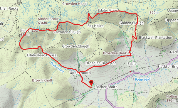
Route Description: From Barber Booth parking start by initially following the single-track road up the valley. By the farmhouse at Upper Booth go through a gate on the righthand side and join the Pennine Way as it climbs gently up the hillside towards Edale. The path is easy to follow as it contours round the lower slopes of Broadlee-Bank Tor. The path here is on farmland and crosses several gates as it drops down towards Edale. Eventually a narrow walkway beside a small stream is reached. This takes you to the edges of Edale village proper.
Once you reach the road, turn left onto it and follow it for about 200m before another footpath in reached on your right. The footpath initially drops down via stairs to a footbridge crossing the stream – climb back up on the other side and follow the path as it starts to head up towards the moor. Very soon another footpath forks off on the right and climbs steeply up towards Ringing Roger. If the weather is clear you can see the path as it zigzags its way up the hill. About 200m through the climb, cross a gate into the Open Access land. After the zigzags a number of smaller paths fork of the main path and there is a chance to pick you own way up as these will all eventually join the main path up at the edge of the moor.
Once the edge is reached, turn left onto the path running along it. Enjoy the views over Vale of Edale and the interesting and varied running the edge offers. The landscape of the moor is complex, and the path keeps winding through the peaty ground making its way up and down. Keep following the edge around until you reach the top of Grindsbrook Clough. This allows for relaxed running without the need to consult a map! After Grindsbrook Clough some care is needed in order to keep following the path up the moor in a westerly direction. Here it is easy to accidentally take one of the paths leading to Grindslow Knoll and back down to Edale. This is an easy place to shorten the run if necessary and the trot down the fields is pleasant and takes you back onto the Pennine Way just before it reaches Edale.
If, however, you have decided to stick with the original run plan the path will quickly re-join the edge after the Knoll and continue until it crosses the top of the next brook (Crowden Brook). After this the path will weave itself across the fascinating rock formations known as the Wool packs. Pick your way through these continuing in a westerly direction for another kilometre before the path joins with the Pennine Way.
Turn left down rocky steps and follow these into a junction with the bridleway and follow it down to Jacob’s Ladder. Note that at the waymark of Jacob’s Ladder, the footpath forks left taking a steeper descent down towards the brook. For a less steep gradient, the bridleway turns right diagonally down the hillside. They meet at the bottom for a final river crossing via a good footbridge before a bigger track is reached. This will keep following the hillside above the stream as a gentle downhill which gives this run a pleasant finish. Pass through a farm and join a small single-track road back to the parking via Upper Booth.
Access: You can start this run from the free carpark at Barber Booth. Note that it is accessed by a single-track road which frequently gets very busy – please park considerately and do not block the road or passing places. The parking at Barber Booth is also often full especially at weekends. An alternative starting point is Edale village where both paid and on street parking is available. Edale can also be easily accessed by both train and bus.
4. Stanage Edge
- Distance: 8km/5mi Elevation gain: 230m/760ft Trail surface: Mix of gravel road and rocky/muddy paths Difficulty: Easy/medium
Route Summary: A there and back run along the top of Stanage Edge.
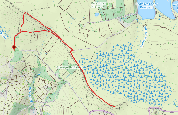
Route Description: This is a Peak District trail running classic! One of the shorter runs listed here but full of interest and worth it already for the excellent views. I prefer parking in the small car park below Stanage High Neb. It is known locally as the Dennis Knoll Car Park but labelled as the Long Causeway Car Park in Google Maps. Parking here is free but often full as the location is popular for rail running, walking and rock climbing. However, considerate parking on the verges is also possible. From the car park join the gravel road past the barrier and follow this until a big stile on the lefthand side allows access to the moor (roughly 500m). (There are two stiles near each other, take the second one). Follow the path uphill through the ferns until it reaches the bottom of the gritstone edge.
Continue slightly rightwards to pick your way up the final steep section via easy ground. I like to initially turn left and follow the top of the edge for a few minutes to reach the trig point at the top of High Neb. But you can also turn right immediately on getting to the top of the edge. Simply follow the edge until a second trig point is reached at the south end of Stanage before turning back. The only point involving route finding is after the path joins onto the Long Causeway for a brief period. When the causeway turns left and away from the edge it is important to turn right onto the smaller path which crosses a fence line and keeps parallel to the edge. On the way back I usually join the causeway for a pleasant and quick finish down to the car park.
For longer options of this run; it is easy to continue further from the trig point at the south end of Stanage. Run towards the Upper Bridge of Burbage and do a loop of the Burbage valley before returning the same way.
Access: This run is most easily accessed by car. Parking can be found in several places along the Stanage Edge. These include the Dennis Knoll carpark, shown here as the starting point. As well as a large car park at Stanage Plantation and free parking at Stanage Popular. You can also park at Upper Burbage Bridge (often busy) and join a path to the south end of Stanage.
5. Bleaklow from Snake Pass
- Distance: 8km/5mi Elevation gain: 135m/450ft Trail surface: Mix of muddy and rocky paths. Difficulty: Medium
Route Summary: A there and back run to Bleaklow Head from the Snake Pass.
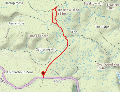
Route Description: This run gets you to the top of another one of Peak District’s most know hills, Bleaklow (633m). Sometimes I want a trail run with the feeling of remoteness without too much elevation gain. For those days Bleaklow is an ideal choice. The landscape is complex and remote but the starting point high up on the Snake Pass cuts down the overall elevation of the route to a very manageable 135m/450ft.
The route starts from a lay-by at the top of the Snake Pass and follows the Pennine Way north. Follow it until a vague path forks left towards the distinct outcrop of Hern Stones high above the surrounding moor. From the stones follow the faint path northwards to the Wain Stones. Continue past these as the landscape suddenly becomes rockier and dried. The path will continue north-east and quickly take you to the big cairn and stake marking the summit of Bleaklow. Turn back but this time choose the bigger footpath leading back towards the Snake Pass. The main footpath is the usual route for people walking the Pennine Way. It is in places rocky, crosses multiple little streams and can be hard to run after periods of rain. Follow this all the way back to the Snake Pass and your car.
Note: don’t be fooled by the relatively short length or the low overall elevation gain of this route. The complex landscape of Bleaklow will make your legs feel like they have been on a much longer run! Bleaklow is a devious little hill and can catch out even an experienced navigator. This is especially the case when the weather comes in which can sometimes happen in the matter of minutes. Therefore, it is important to be a competent navigator if you wish to leave the Pennine Way and explore the smaller paths. Including those leading to the Hern and Wain Stones described here. However, despite the complexity of the landscape, or maybe due to it, Bleaklow is great for trail running.
Access: This run is most easily accessed by car. Parking is at the top of the Snake Pass (A57) in a popular lay-by on either side of the road at grid reference SK 08796 92917.
Bonus: Trail Running in the Upper Derwent Valley
I couldn’t resist adding in a little extra! The Upper Derwent Valley is an ideal location for trail running in the Peak District. There are various car parks available either along the road or at Fairholmes. It is possible to do a fairly flat loop around the Derwent and Howden Reservoirs at roughly 16km/10mi. For additional distance start from the Ladybower bridge and go around the Upper Ladybower Reservoir too to make a loop of 24km/15mi. The route follows a tarmac road for the section on the west side of the Howden and Derwent Reservoirs. However, due to well-worn paths on the verges it is possible to stay off the tarmac for a majority of the way.
Note that the road is closed for traffic at Fairholmes on weekends and bank holidays. This means no need to negotiate cars on these days! For runs with more elevation there are numerous footpaths which allow access to the Alport Moor, Howden Moors and the Derwent Edge. The opportunities here are endless to design a run that will suit your requirements!
Access: It is easiest to access the Upper Derwent Valley by car. However, with some planning it is possible to get a bus to the Ladybower Bridge. On Sundays there is also an extra Sheffield – Castleton bus which will stop at Fairholmes few times during the day.
For more inspiration, ideas and Peak District trail running follow me on Instagram and Pinterest and subscribe to the Hill Days Newsletter for extra updates!